Platform Development to Provide Disaster Prevention Information and Analysis/Prediction Data Visualization of Local Risks, Support Disaster Response, and Disaster Prevention Activities
Release:
Update:
NEW
NEEDS
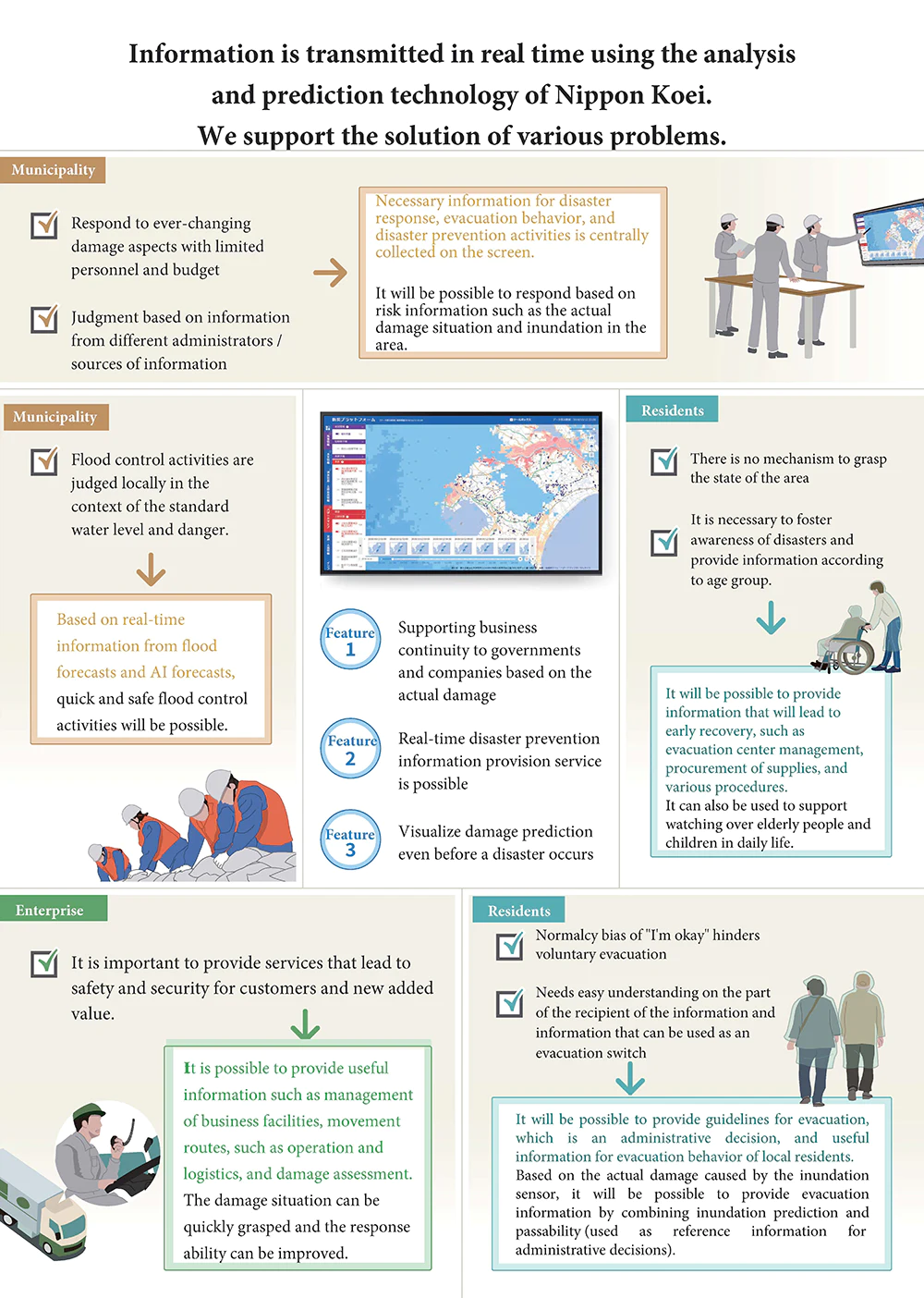
Centralized Collection of Risk Information Such as Flood Damage and Damage Information That Differed for Each Source
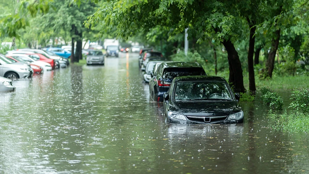
What do people do when a natural disaster occurs, such as when it is raining heavily? Perhaps most people will try to gather information from news sites and public sites, as well as use SNS to grasp the current situation.
Nowadays, unlike the times when only TV and radio were used, various methods of transmitting information have been developed centering on the internet. It can be said that we are in an era where anyone can easily obtain a lot of information. In other words, there are multiple sources of information. As in the above example, it is attractive to be able to collect information from various angles, but there is also the drawback that we may have to deploy many apps and browser tabs and we cannot obtain powerful information effectively.
In addition, sources differ in the accuracy and directionality of their information. For an extreme example, let us assume that there is heavy rain. Information from the government and river offices are very accurate in terms of accuracy. However, it is a fact that it is difficult for citizens to make use of numerical information such as the amount of rainfall in millimeters and the river level in meters. On the other hand, on social networking sites, we can see pictures of rainfall that we cannot even see in front of us, or pictures of rivers that are about to overflow. Although we cannot see the numerical values, we can know the urgent situation in real time.
It has been difficult to consolidate and handle the ever-changing data from different sources. Moreover, it has become a big problem that the current situation is that the normal bias of " I am fine " has been inhibiting voluntary evacuation.
In order to solve this problem, Nippon Koei selects lots of information and integrates them on the screen. For this purpose, we have developed " Bosuke " (trademark pending), a water disaster prevention platform that incorporates the analysis information we have cultivated through our disaster response work and research and development.
SOLUTION
A Platform Equipped with Additional Functions Based on Water Level, Flow Rate, and Flood Forecast Information.
The major themes shared by the team in the development of "Bosuke" were:
① What kind of information should be provided to encourage voluntary evacuation;
② Timely and easy-to-understand information that can be checked conveniently;
③ Visualization of various numerical data;
④ A wide variety of options, such as satellite or SNS-based disaster monitoring and AI analysis;
⑤ The implementation of cloud services will reduce the management cost to about 10% of the conventional cost, and;
⑥ the acquired information can be easily changed and flexibly linked with other companies' cloud services.
The "Bosuke", which combines these advantages and provides information to local governments and private companies in a one-stop service, was developed by the Digital Innovation Management Department, which consists of experts from various related departments. This was achieved by consolidating the knowledge that was scattered throughout Nippon Koei.
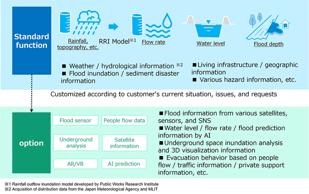
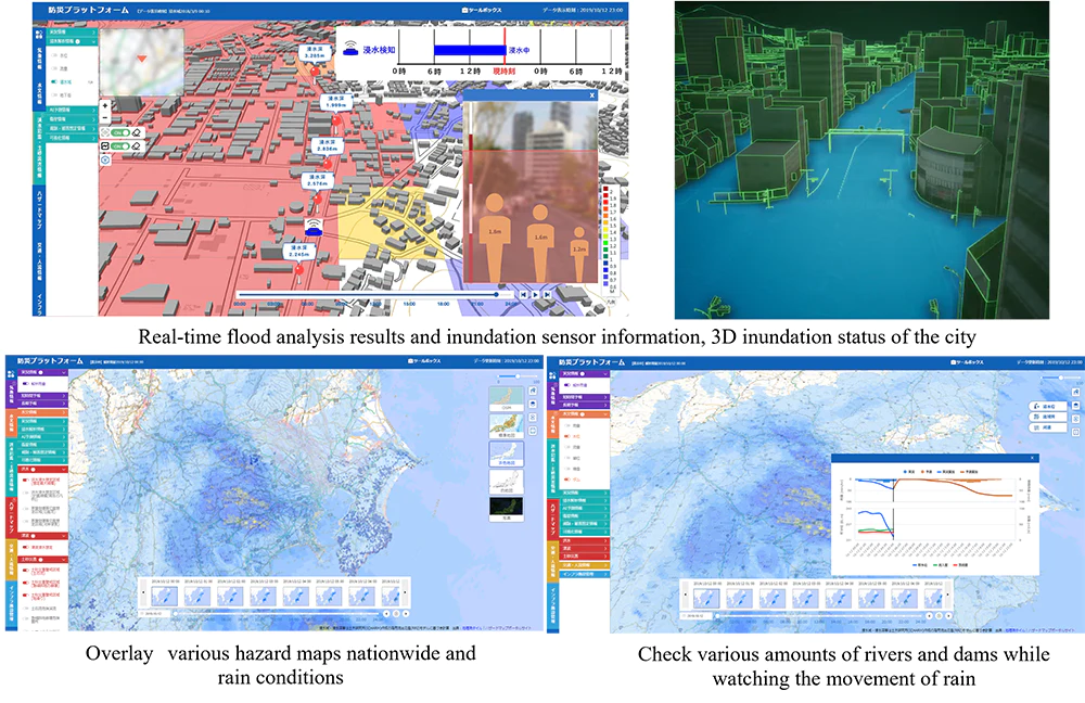
The standard function is to input rainfall, flow rate, water level, and inundation depth data into a map with topographical and other data, and you can get water level, flow rate, and inundation forecast information based on real-time analysis.
Also, additional functions can be customized to meet your needs by combining technologies such as inundation sensors, AI prediction, satellite information, underground city analysis, human flow data, probes, and AR/VR. By overlaying meteorological and hydrological information, flood inundation and landslide disaster information, and infrastructure information on a map and displaying them centrally, the system supports disaster response, evacuation behavior, and disaster prevention activities that lead to the safety and security of the community.
POINT
“Bosuke” Platform can be Deployed in Other Fields, not only Flood Control
We realized that the knowledge accumulated in each department of Nippon Koei had not been widely utilized, then the project was started. Each department had always been working hard on their tasks. But it is also true that once the work was done, the knowledge and research results obtained were buried in the daily work. The Digital Innovation Management Department aims to find the assets of the company's technological capabilities that have been lying dormant in each department, skewers them horizontally, and conducts development to create new value for society.
As a result, "Bosuke" was developed. There is already a movement for joint development and demonstration with major telecommunications companies and electric manufacturers working on social infrastructure. In addition, a demonstration experiment for a flooding sensor is underway in Shizuoka City. Although we have not yet experienced heavy rainfall that would allow us to live up to our predictions, we are ready for any eventuality.
Still, we are not satisfied. As a platform, we are barely at the starting line. Although "Bosuke" was developed as a platform for water-related disaster prevention, we are already looking at interlocking services that will work well together, such as monitoring evacuation status on land and family monitoring services during normal times. Please keep your eyes on "Bosuke" since its development will continue to be accelerated and become more connected to the community.